Resident Artist Research Project - Bell Museum

2. Seven Mile Creek - A Deeper Look at the Land Near Home
Seven Mile Creek County Park is on ancestral lands of the Dakota between Mankato and Saint Peter in Nicollet County. The heart of the park is a creek that collects the waters from a 23,000-acre watershed and sheds them into the Minnesota River. The 6-mile long creek is, ironically, called 7-mile Creek as it was located seven miles from the courthouse in St. Peter. I have unsuccessfully wandered old maps for a less arbitrary name for the creek, perhaps describing the character of the area, or what the local Dakota called the creek.
The park is essentially a series of forested ravine fingers draining the watershed from high-prairie farmland to seven-mile creek, an incised stream running west to east and emptying into the Minnesota River Basin which flows north to meet the Mississippi River at Bdote Minisota. The majority of the 630-acre expanse is along the namesake creek and its trickling tributaries, but there is also a section following the sandy banks and cottonwood floodspace along the Minnesota River.
Before colonization, the watershed surrounding the park was mostly prairie, wetland, and oak savanna with some lakes and sections of the late great big woods that once stretched across southern Minnesota. Today most of the wetland is drained, the big woods are gone, and 80% of the land is corn and soybeans. It’s the story of the Midwest, tillable land is tilled, lakes and wetlands are drained, the hardwood forests are left to the ravines and margins. Despite these facts, the story is changing, becoming more complex and hopeful.
Some farmers are working with the 7-mile creek Watershed Partnership to improve water quality while keeping the soil in place and reducing erosion. Some use cover crops and or have dialed-in drainage systems to manually control the water table below their crops. This allows them to limit water flow to the ravines during storm events.
The relatively small watershed and park have actually been studied extensively. I see students from Gustavus Aldophus College taking water samples or researchers from the University of Minnesota conducting surveys. I met a graduate student doing a poster presentation on the park some 450 miles away at Michigan Tech. I gather that the park is a sort of farmland/watershed case study in a system similar to many other places with similar problems.


Beyond a spattering of glacial boulders, Jordan sandstone is the visible outcropping of rock in the park. It ranges from tan to bright white. It’s soft enough to carve with a stick in many places, and park goers cannot resist gouging their initials in the eroding rock. The limestone local to this area, kasota stone, once blanketed the sandstone. It likely washed away around 10,000 years ago when the glacial River Warren escaped the great glacial Lake Agassiz forming the Minnesota River Valley.

Jordan sandstone on south side of creek in June
The forest is composed of mostly northern northern red oak, hackberry, maple, basswood, boxelder, elm, ash, hickory, cottonwood, some aspen, a few patches of birch, some bur oak, some Kentucky coffee tree, some black walnut, some sumac and willow on the fringes. The largest known cherry tree in Minnesota is in the park.
Spring brings trout lilies, wild ginger, ramps, blood root, bell wort, ostrich ferns, jack-in-the-pulpit, trillium, dutchmen’s breeches, virginia waterleaf. And a little later columbine, maiden hair ferns, horsetail, honeysuckle, black rasberries, and unfortunately loads and loads of stinging nettle. In the prairie patches, black eyed susan, coneflowers, fleabane, bee balm, golden rod, milkweed and much more.

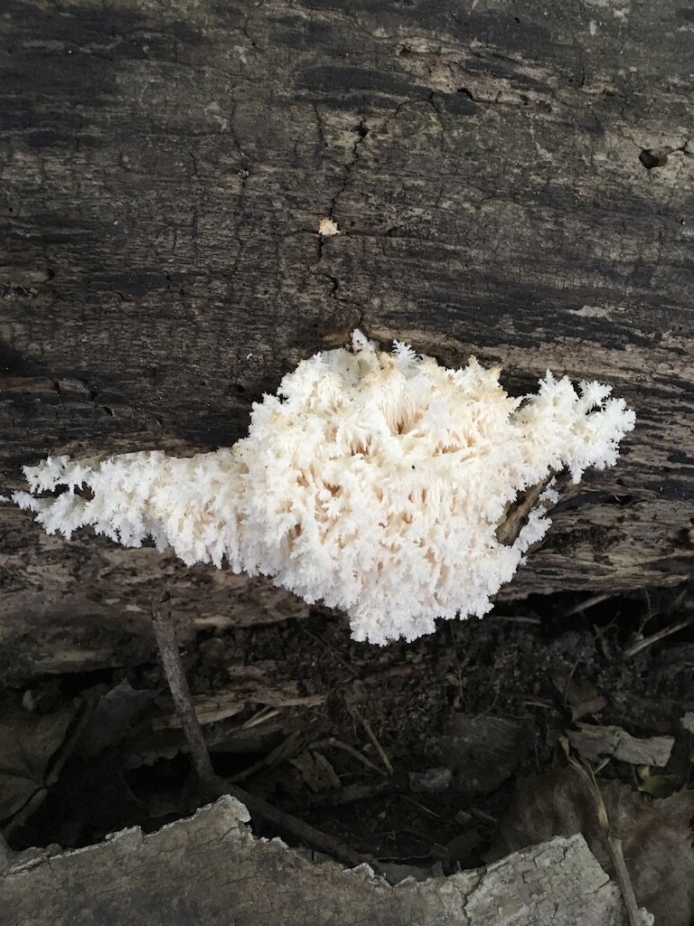
Young lions mane mushroom, a delectable edible, starting on rotten log in early September
Morels round the dead elms the 2nd week of May as pheasant backs protrude from elm carcasses and oysters cantilever off elms and other hardwoods. From late May into June-September, chicken of the woods grow from dead/dying red oaks/bur oaks. In late June early July, coral rise from rotting logs, and chanterelles begin to fruit around living red oaks. From late summer into the fall I find puffballs and hedgehogs. In the fall come bears head and lions mane. While other forests in the area have porcinis (king boletes), hen of the woods, and more significant patches of chanterelles, these species are limited in 7-Mile.
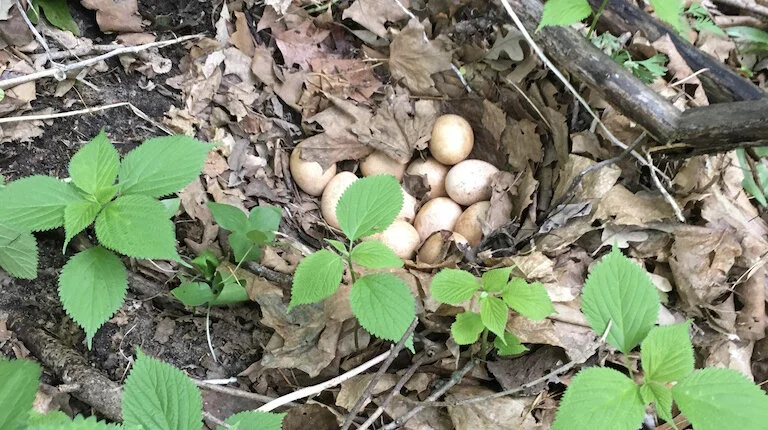
Turkey eggs on forested ravine in late May
Wildlife in the park ranges from birds to mammals to amphibians. I’ll list a few that I see regularly. There are gray and black eastern gray squirrels, red squirrels, chipmunks, raccoons, garter snakes, northern leopard frogs, toads, opossums, barred owls, several types of hawks including the northern harrier and red hawk, loads of pileated woodpeckers, loads of white-tailed deer, turkeys. A rare black bear was spotted in the area last fall, but I have not been lucky enough to see it or its scat. Most the beavers in the park have built lodges into the banks of the Minnesota River, but I have seen recent evidence of them heading up the creek.

Cottonwood beaver kibble on the western bank of the Minnesota River in early March
While I have shared a number of facts about this land, the information above has mostly been filtered through my own naive experiences, and I had some help with flower ids from Rachel James. For a deeper dive into the research from professionals follow the links below.
Park Map / Brochure: https://www.co.nicollet.mn.us/DocumentCenter/View/4670/Seven-Mile-Creek-Brochure
Bird Checklist from park: https://www.co.nicollet.mn.us/DocumentCenter/View/4669/Seven-Mile-Creek-Bird-Checklist
Seven mile creek watershed partnership: https://www.7-milecreek.org/
Interactive Park Map: https://mrbdc.mnsu.edu/sites/mrbdc.mnsu.edu/files/public/major/midminn/subshed/sevenmi/vtour/parkmap.html#
Another interactive tour of the park and watershed: https://mrbdc.mnsu.edu/sites/mrbdc.mnsu.edu/files/public/major/midminn/subshed/sevenmi/vtour/smvt_2.html
Actively incising river evolution... in central Minnesota by Karen Gran, University of Minnesota Duluth: https://serc.carleton.edu/vignettes/collection/25560.html
An interactive site about water monitoring throughout the creek: https://www.carleton.edu/departments/geol/Links/AlumContributions/Antinoro_03/SMCwebsite/index.htm
Plants and Flowers: https://www.minnesotawildflowers.info/
Link to some of the glacial history in the area, the great glacial Lake Agassiz, and the glacial River Warren that formed the MN river valley: https://mrbdc.mnsu.edu/minnesota-river-valley-formatioa